Return to the South Blind 35 Mountain
Sometimes I miss the good spots on a hike. I often head into an area with little more than a topographic map and a rudimentary understanding of the area. Depending on how the hike goes my rough plans can change rapidly to avoid rough sections or check out an interesting side destination, but many times I don't recognize the better routes until the adventure is over. This can get frustrating when I'm considering revisiting a mountain. I've climbed Bald Mountain by Big Eric's bridge almost a half dozen times thanks to bad weather, over-exertion, or just plain curiosity about that one spot I never noticed before (and yes, I do plan on returning to Bald Mountain again in the future). This afternoon I ended up tackling a particular tough climb just north of the Yellow Dog Plains after a surprising discovery.

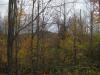
Dead grass and sand on the Triple A
The hills of Blind 35 is a spot I had hiked before. Two large, varied mounds of rock rise up around a dead end road west of Big Bay. I've been to different sections of the northern mountain a few times and have enjoyed the sweeping views and rugged outcroppings, but the southern one was disappointing. A single obscured view north to Lake Superior (and an encounter with a bear and her cub) was a big letdown compared to the broad ridges less than a mile north. When I last left Blind 35 I wondered how two hills so close together could offer such different hiking experiences.
There are a few small rocky hills located between the start of Blind 35 and the Triple A road. One of the hills is frequently used by Northern Michigan students for rock climbing. After seeing some promising photos on a geocaching site I decided to check the hills out, parking just off an unnamed two-track on a cool spring afternoon. There were some young adults playing on the first hill so I continued down the worsening road, stepping over ruts that would have seriously hurt my little car, on my way to a tiny rise of rock just high enough to offer some views of my surroundings. My route was an easy walk that meandered for close to a mile before a slight outcropping peaked out from the trees. What I saw from here changed all my plans for that day.

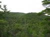
Few small ridges to the north

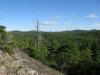
Unexpected steep mountain in the west
This tiny rise gave better-than-expected views east towards Lake Superior, but the real shock lay to the west. A huge mountain rose up with a sudden south-facing cliff amid multiple prominent outcroppings. Realization slowly dawned on me… this was the southern Blind 35 Hill that had appeared so ordinary before. On my previous visit I stuck to the north slope and never climbed all the way to the peak. The north side was a slow, gentle slope with a few scattered bumps, and I had assumed the entire mountain was forested and tame. Seeing what I had missed on my last visit, I quickly decided to take on the challenge and I reviewed my maps, plotting out the new hike.
I knew a swamp lay between us so I headed northwest first along a logging track from my little rise. This track looped back around to Blind 35 but took me within a half mile of the mountain first. After this easy sandy walk I cut into a young forest, crunching and snapping through the undergrowth. Thankfully I was far enough north to avoid the swamp and ended up at the base of a towering, humbling wall of rock sloping out of sight above me.

Rock rising suddenly from the forest floor
Excited to tackle this I veered slightly to the left before starting up the steep climb. Scrambling up on all fours I made it up the first rise and was greeted by some amazing views east and south. I took a quick break to catch my breath, then continued west, up another sudden rise onto the second outcropping, with more and more views opening up with every couple of steps. This was the type of climbing I truly enjoy, a tough, rugged slope with no trails and exciting discoveries every couple of yards.

Looking east from the shoulder

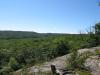
More hills in the north
After the second outcropping the slope lessened a bit. I was still heading uphill quickly, but now I was surrounded by huge pines and thick woods. My early aggressive approach started to wear on me. Using trees and a walking stick I pulled myself higher and higher up the mountain, ignoring my tired legs, until I suddenly came out onto the edge of the cliff I had spotted before. The wind whipped around me, threatening to toss my hat over the edge, as I stumbled over to a bench. Wait, a bench?

A bench on top of the cliff
Somehow a bench had shown up on the edge of a steep cliff with no trails or reasonable explanation. I didn't bother to puzzle over it too much and sat down, enjoying the eastern view. I could make out many unnamed hills and outcroppings but could just barely make out Big Bay and Lake Independence in the distance. To the south a jumble of different mountains and hills slowly rose towards the flat line of the Yellow Dog Plains.

Lake Superior glimpsed to the north

Swamp and hills in the east

Hill rising just to the south
The cliff led to the west and I followed, getting occasional new views south and west. The sun shone brightly to the west, obscuring some of Huron Mountain Club mountains, but the closer Snake Creek Hills and Ives Hill felt close enough to reasonable tackle today if it wasn't for the late hour and my tired legs. I ventured close to the south edge a few times to peer down, cautious of the rounded edge and stiff winds. When I reached the western end of the cliff and I was tempted to turn north and follow the next ridge. I suspect I'll be back in this area to tackle more of the Snake Creek Hills, so today I started heading down the steep cliff carefully on unsteady legs.
I reached a saddle south of the cliff and headed east, back to the logging roads. This time I circled south around the bog, along sandy roads, and made it back to my car in a respectable time. On the way I planned for future visits to this area. I'd like to make a serious attack on both the south and north hills of Blind 35, searching out all the outcroppings on this hills, and still need to hit up the little spurs in the area. While today was a brief visit that I'll be repeating eventually, I was still incredibly pleased with the change of plans and being proved wrong about how ordinary I thought the southern Blind 35 mountain was.
-
Jacob Emerick
Aug 9, '13
From 1946? Wow! That's an impressive stretch. I'm sure you have plenty of good stories about that road and area... There is a lot of little hills and outcroppings on both sides of Snake Creek, this hike was the barest brush of some of the land up there along Blind 35. If you don't know who put the bench there I'm starting to wonder if the darn thing just grew right up from the rock! ;)
-
Andy
Jun 15, '15
Hi, pleasure to find your site. I grew up in the UP and return every summer. I'm planning a trip to check this area out as it somehow eluded me during my entire upbringing in Trout Creek. What I'm wondering is if there is a drivable route from Big Bay (or just south of Big Bay) to the Skanee area. I'd just like to do a daytrip through the area to see what it's like, and I'd hate to get 20 miles down a road only to have to turn around at one of HMC's gates. Is there a summertime passable route from the blind 35 area to Skanee? My vehicle is a smallish 2wd SUV with decent ground clearance if need be.
-
Jacob Emerick
Jun 15, '15
Hi Andy, great to hear from you! There are a few driveable routes that connect Big Bay to Skanee, though none of them go along Blind 35. Once that road goes over Snake Creek it gets really nasty really fast. The best way is to take the AAA (now paved, thanks to Eagle Mine) from 550 onto the Yellow Dog. Then, about five miles past Eagle Mine, turn right on Ford Road and take it right up to Big Erick's.For a bit more excitement you can always jump on the Northwestern, which follows the north side of the Yellow Dog, and is close to Blind 35. However, that road is more suitable for ATVs than cars :)
-
Andy
Jun 15, '15
Thanks for the reply! I scoped out your route as best I could on Google maps and will for sure hit up the ranger station in Kenton for some maps and additional guidance before I head out. Would you say it's worth the drive to check out Big Bay? Is there anywhere there to grab a quick lunch or dinner by any chance? Also, are there any sights along your proposed route you recommend stopping to check out? Sorry for the barrage of questions, but I'm gonna be in the UP in 4 days, so I'm starting to get pumped for this little road trip :)
-
Jacob Emerick
Jun 16, '15
Hi Andy,Yes, it's definitely worth checking out Big Bay. There's not much in town, an old sawmill that you can't get too close to, but there is a nice bar (Lumberjack Tavern) that I've heard has excellent food. Plus, Thunder Bay Inn has a movie filmed there. You can always zip down to the beach too, if you're looking for a view of Lake Superior and up the cliffs along Salmon Trout Point. On your way up 510 towards the AAA there is Gobbler's Knob (now called Thomas Rock), a well-marked overlook of the town and bay.Oh, and if you can find the right track, Pinnacle Falls is well worth stopping at. After you get on the Yellow Dog Plains but before passing Eagle Mine there is a sandy track that leads left to the edge of the plains and an impressive waterfall along the Yellow Dog River. Further on the drive is the McCormick Tract and a few other cool waterfalls, though they are a longer walk along an unmarked path, so I'm not sure if you'd want to tackle that.If you haven't been to it yet I'd recommend checking out Mouth of Huron once you get across Big Erick's Bridge. It'd be a great place to relax after the drive and look out towards the Huron Islands. As long as the black flies don't carry you away, that is :)Feel free to ping me with any more questions, Andy! Oh, and if you're using Google Maps, don't trust the road names too much... Few, if any, of those roads have reliable names. Mileage is the best way to track where you're at.
Add to this discussion