Cookout Mountain and the Hidden Falls
There is a small mountain and tiny lake located on the western end of the Trap Hills right off of M-64. A blazed trail leads up from the road to the mountain, passing near the lake, before it heads south to the North Country Trail. Known by locals as Cookout Mountain and Weidman Lake, this area first drew my attention during a winter waterfalling adventure.

Snow covered Weidman Lake
Starting in a muggy mid-morning summer day, I climbed the trail from the road and soon came to a tiny trickle of a creek. White rectangles nailed on the trees continued across the creek and up the next hill, but I turned away from this path and started heading upstream. The undergrowth was not particularly thick, but the creek had a most annoying twisting route within a tiny valley that forced me to repeatedly cross stagnant pools of water and mossy rocks. Attempting to cut straight paths parallel to the creek quickly led me astray, as it was difficult to make it out the creek's path from more than ten feet away. so I continued upstream along and across the creek slowly and painfully.
During my waterfall search I found a listing for a waterfall known as 'Hidden Falls'. There was no description or location of these falls asides from a generic listing under Ontonagon County, but I continued to keep my eye out for clues that could help me find it one day. Finally I found a mention of the falls in a hiking pdf about the Trap Hills area. Hidden Falls was located below Weidman Lake, along its outflow channel. It was late winter, with a thick covering of snow just beginning to melt, but I headed out past Ontonagon to find it. After hiking up the tiny creek, which had a small but noticeable flow with the warming weather, I was disappointed to find two drops completely covered in snow.
The muggy weather started to break with a slight sprinkle by the time I reached the first drop over jagged, mossy rocks. This total drop was less than four feet, split up between several brown rocks. The trickle was only enough to be visible for a small portion of the drop, disappearing under the rocks before collecting a stagnant pond below the falls. The upper drop, located a short distance upstream, was only slightly better. Though smaller in total size, the water spread evenly to coat a narrow section of the sheer rock.

Hidden Falls upper drop
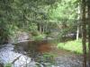
After finding both falls audibly gurgling but visibly hidden by the snow I decided to continue upstream to find Weidman Lake. I had hopes of finding something worth the snowy trek and long drive out here. The lake was interesting - completely snow-covered, it had the sporadic dead trunks sticking out at random angles from the snow-covered surface. A long beaver dam held back a good chunk of water, undoubtedly giving the lake quite a bit more surface area than normal.
Following in the footsteps of my winter hike, I continued upstream to the lake through a gathering rainstorm. The beaver dam was still intact, but the lake lost some of it's beauty in the green of summer. The dead trunks did not stick out like last time, and the bright green surrounding the lake seemed in disconcordance to the lovely death of winter that I had enjoyed before. I quickly turned about and headed downstream with a eastern veer, away from my car. There was one more place to visit.

Weidman Lake in summer green
The deep snow and long hike left me a depressing hike back to the car. I tried a shortcut to the west, a beeline back to the car, which took me through a softening swamp and through some thick trees. There was an interesting abandoned hunting camp along the way, complete with a ripped tarp tent and random junk strewn about, but in general the return was difficult and tedious.
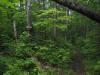
My rainy summer hike slowly calmed down to a gentle drizzle, but the previous rain and thick undergrowth had already soaked me to the skin. Climbing the eastern hill of the creek was generally easy with a few steep sections separated by long flatter areas. Before I knew it I was standing upon the tallest point of Cookout Mountain, with a large boulder as my only interesting companion. Heading further south brought me back to the white blazed trail I had left back at the creek, which led me to a variety of amazing views of the northern Lake Gogebic area.

South from Cookout Mountain outcropping
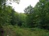
This time my return to the car was much shorter and more scenic. For a short time I was greeted by different southern views off of Cookout Mountain, and afterwards I quickly stumbled back upon the famaliar creek. The northern spur, which brought me to Hidden Falls and Wiedman Lake (and consisted the vast majority of my winter hike) took well over half of summer hike. Overall, though, I was pretty happy with the route I chose - I finally saw the Hidden Falls and got to climb a mountain on the way back.

Comments (0)