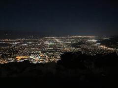
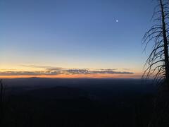
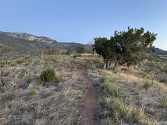
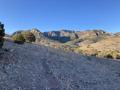
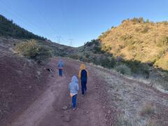
Western Alder Hill

Both Alder Hills are located in a prime area for promising views. Being near the northeast corner of the Huron Mountains lends potential for vistas of Big Bay and Lake Independence with enough elevation to glimpse the edge of the Yellow Dog Plains. One could easily expect grand views and well-traveled paths on both peaks. My earlier climb up the eastern Alder Hill proved disappointing, with fleeting glimpses of the lakes to the east at best. I was not sure if the western hill would hold a similar outcome, but I wasn't about to climb the taller 1400 foot peak without confirmation that there was at least one good outcropping to find.

Many outcroppings on the south face

Many outcroppings on the south face

There is a small parking spot where the Triple A ends at County Road 510 with a four wheeler/snowmobile trail leading into the woods. This path roughly parallels 510 southwards from here in what I'm assuming is a normal trail for snowmobilers coming off of the Yellow Dog plains that want to avoid riding on the road. I parked here and followed it south, slowly walking past my ...

read more »
  • Tags:

Eastern Alder Hill

County Roads 550 and 510 stretch northwest from Marquette, roughly parallel and never more than five miles apart, eventually meeting near Big Bay. Between the two roads lie a number of public and private peaks of the Huron Mountains. There are a few that spill out of the road's embracing circle, but for the most part there is sandy lowlands to the east of the roads and highlands to the west. I've been to a lot of the accessible areas between these roads, but there were two new ones that I aimed for today - the Alder Hills.

First view of the southeast Alder Hill

First view of the southeast Alder Hill

I parked at a familiar spot above Alder Falls. The sandy road from County Road 550 is a bit of a tough stretch for my little car and I didn't want to try my luck driving beyond the falls. Grabbing my gear I headed uproad, past the trail down to the waterfall, and towards the eastern Alder Hill. After a short distance uphill on the road I cut south on a track, catching a quick glimpse of the impressive hill in front of me. It would be a good 500 foot climb to the peak on this hot and dry ...

read more »
  • Tags:

Return to Mulligan Cliffs

The cliffs along the southeast wall of Mulligan Plains is one of the most rugged and tempting hikes I've found since I first viewed them in late 2008. Towering hundreds of feet above Mulligan Creek, often with sheer rock faces that are rare in the Upper Peninsula, they promise of awesome views of the plains below and hold back wild, unvisited highlands spotted with swamps and lakes. This area has multiple impressive cliffs near Stager Lake and Red Road, but these cliffs are the tallest and most difficult to visit.

Up at one of the bluffs

Up at one of the bluffs

I had spent the night next to the Rocking Chair Lakes. My journey up here had not been easy, with several clumsy stumbles into swollen, thigh-deep puddles in the twilight. Waking slowly with the wet, foggy morning I ventured south along the ridge line. It was slightly tempting to climb one of the two outcroppings on the east side of both Rocking Chair Lakes, both of which offer a commanding view of the plains below, but my hike today was a long one. I was planning on backtracking my ...

read more »

Mount Mathew

Mount Mathew is located just north of Three Lakes within a few miles of Marquette, Michigan. Less than a thousand feet in height, it is dwarfed in both stature and awareness by Sugarloaf and Hogback to the north. Even the Three Lakes area is only known by its closeness to the Dead River Falls upstream. Even though I had suspected that it would be a good hike, it wasn't until I found a geocache located on it's summit (along with a promise of a path up) that I decided to visit the small peak.

Southern view towards The Sands

Southern view towards The Sands

I parked just off of the familiar Forestville Road (which leads from Wright Street to the Dead River Falls) where a county road breaks off to the north. This is also where the Lake Superior & Ishpeming tracks are clearly visible from the road which would serve as my route to the mountain. I don't necessarily like following train tracks - they're not the easiest or most enjoyable thing to walk on (you'd be surprised how much the ties move around over time) and I'm constantly worried that a train is going to sneak ...

read more »

Product Development and Intelligence

My career in web development started with delivering products, not necessarily expectations. Starting as a lone web developer I've previously made the mistake of trying to put the product specifications before the client needs, focusing on what I can do technically and not what I should be doing to fulfill their requirements. Working at DealerFire has helped me start with the client expectations and work backwards to what we can do to meet them (which is how it probably should be, although this can easily result in a mismatch of perceived value and actual value). Thanks to a recent promotion, I'll be moving up to the next tier of delivery and responsibility - product intelligence.

When you work in a web development environment there is always a limit on what is possible with finite resources. That's something that holds up a lot of beginning developers and companies - getting caught up on the limits of what they currently know. Without full knowledge of current technologies or industry movements, it's easy to fall back on known territory and ...

read more »

Return to Bald Mountain

Three years had passed since I last climbed Bald Mountain, the last significant outcropping of the Western Huron Mountains. My first visit was a significant milestone for me, as it was the first non-waterfall hike I attempted in the Upper Peninsula. This initial climb triggered a long and lasting interest in the Huron Mountains and other UP features that still drives the majority of my hikes. Today I was revisiting Bald Mountain in the winter again both to commemorate the anniversary and find something that eluded me three years ago - a clear view of Lake Superior to the north.

First view of Bald Mountain

First view of Bald Mountain

Leaving my car just off of Erick's road, where snow plows had cleared some extra room at the two-track leading to the mountain, I headed north along week-old snowmobile impressions. The snow was not deep with this winter's frequent melting spells and the few times I stepped off the snowmobile tracks I only sunk down a foot or so. A few animals also used this two-track (left from the Mead forest planting just south of ...

read more »

Dead River Falls

The sun had barely reason on this brisk fall morning when I stepped out of my car. I debated throwing on a fleece under my worn-thin jean jacket but decided that a quick-paced hike would keep me warm enough. Today would be started off with a visit to the familiar Dead River Falls, which had been closed off for penstock repair for the better part of a year. Not only was I curious about the construction that had closed off this popular spot but I also wanted to get some good photos of the waterfalls - my previous visits had been marred by mishaps, poor weather, and access issues.

Early morning sun on the new trail marker

Early morning sun on the new trail marker

There was some modifications immediately visible. After parking in a small parking loop you have to climb up a steep hill to get to the falls. While the climb remains the same, the path up had a slight weave and better foundation to lessen the slope. A cool new marker was also set up in case anyone gets confused where they are.

Winding path up to the falls

Winding path up to the falls

Once I reached the top of the hill I could ...

read more »

SEO Consultants are not Necessarily Experts

I've always been a bit confused by people who consider themselves SEO (Search Engine Optimization) consultants. It's not that I don't think such a position should exists - on the contrary, SEO is an important part of the web development process that is often overlooked by web designers and programmers. What confuses me is how they consider themselves experts.

Most of these consultants devote their focus on Google. This makes a lot of sense, with Google being the elephant in the room when it comes to search engines. However, it seems that the majority of their focus is always on the algorithm and how it changes over time. When Google made the Panda update early in 2011, there was a big push for unique, organic content on sites. SEO consultants seem to be reactionary, watching to see what Google determines is important in determining good content and structure is. This is the wrong approach.

Well-rounded web developers take a simple stance when it comes to SEO. Just build out a web presence that make sense. Each page on a website has a ...

read more »

Blind 35 Hills - South Side

Sleeping in through the cloudy sunrise, I woke up on a rocky outcropping west of Big Bay. I had spent the previous evening hiking around some of the hills on the north side of Blind 35, finding plenty of western views towards Ives Hill and even a limited shot of the Keweenaw Peninsula to the north. You can read about those adventures on my previous post (Blind 35 Hills - North Side). This morning it was time to head south and west to explore more of the hills.

South, across Blind 35, to my morning hike

South, across Blind 35, to my morning hike

I packed up my gear and headed down the steep slope, trotting and sliding down the pine-covered slope to Clear Creek. Leaving most of my stuff in my car, I set a brisk pace westwards along the road past muddy holes and huge rocks far too large for my small vehicle. Blind 35 continued to degrade, slowly resembling a well-traveled four-wheeler path more than the beginnings of state trunkline. After a bit of walking I came to the bridge over Snake Creek, a small two-lane concrete piece ...

read more »

Blind 35 Hills - North Side

West from Big Bay is the Huron Mountain Club, stretching over some of the most pristine land in the Upper Peninsula. An old, abandoned road stretches out towards the club, surrounded by tall, forested hills, before suddenly ending at the property line for the Club. These hills are cut in half horizontally by the road, also known as Blind 35, and range around 1300' in elevation. After a brief visit to some of the northern outcroppings over a year ago, I returned to this area in hopes of finding some good views of Lake Superior and the untouchable Huron Mountain Club property.

Looking east along a steep outcropping

Looking east along a steep outcropping

The drive from County Road 510 is not a gentle one. Blind 35, once the makings of a state trunkline, has been poorly maintained for years. My small car lurched and shuddered over the rutted road as I tried to avoid the large rocks and deeper mud pits. The road is interesting to drive on - it is straight and relatively level, and it's easy to imagine this being a paved throughfare straight through to Big Erick's Bridge. However, in ...

read more »