Planning for Isle Royale
When I first started to mix backpacking with hiking, about four or so years ago, the thought of tackling Isle Royale popped up a few times. I was in the midwest, hiking in the Upper Peninsula, and that island seemed like the ultimate escape from civilization while staying in Michigan. The idea never got that far. Isle Royale seemed too hard for my mediocre survival skills and there were so many waterfalls and mountains to explore on the mainland.
Now, stuck in Arizona, returning to Michigan for a long hike makes a lot of sense. Traveling up there alone is a substantial adventure, one that forces me to think of hiking in terms of weeks and not days. Isle Royale suddenly seemed like a very good idea. Maybe it was time to tackle that challenge, time to see if I could survive in that remote land.
First I needed to do some tests. I've never been a serious backpacker; never spent consectutive days with thirty pounds on my back, constrained to the supplies in my pack. Finding suitable areas in Arizona for backpacking is… a little difficult. Water is the main issue, though high temperatures also limit where and how far I can go. The Cabin Loop up by Mogollon Rim has worked out so far, though it's a bit small (26 - 30 miles total). Ideally I'd like to try out three 15-mile days in a row at some point, which is about the distance I plan to do on Isle Royle. I'm not sure if there is anywhere down here I could try something like and have reliable water sources.
I've learned a lot about my gear already - mostly about its weight. My clothes in particular need some serious attention. Heavy cotton sweaters and wool socks add up in pounds quickly. I'm working on rotating out, starting with obvious upgrades (sleeping bag, mat, etc) and moving towards better clothing options. One of my trips from earlier this summer was around forty pounds and I've already shaved off ten of those.
Food has been a fun experiment. Finding high-calorie, low-weight options is a neat balancing trick. Snickers Bars is a surprisingly good snack, as is the more obvious Clif Bars and trail mix. For dinners I've been mixing my own dehydrated options. Drying out chicken and vegetables, and then tossing in some spices and nuts can make a tasty alternative to Mountain House. So far I think I can survive off of only two thousand calories a day (or about a pound of food), but I'm hoping to test the limit of this before restricting my intake to that.
Even before my tests started, though, I needed to figure out what I was doing. I booked the travel a few months ago, worried about reservations and anxious to get the ball rolling. I'll be flying into Quincy at a dreadfully late hour, arriving around midnight, and will need to find a way to get up to Copper Harbor (Neil's Taxi, probably) for a few hours of sleep before boating out the next morning. Trying to find good days where the airplane tickets were reasonable and the Queen IV was moving was not an easy task. I am a bit worried about the quick turnaround and lack of wiggle room - guess I'll just be crossing my fingers.
My route on the island is ambitious. Most of my hikes are ambitious anyways, so it makes sense to continue that trend. I am hoping to do a full circumnavigation of the island in nine days. From Rock Harbor I'll take Greenstone over to McCargoe, then follow the Minong over to Windigo. Feldtmann will take me around the southwest bump and Greenstone will take me back to Rock Harbor. There are a few options along the way - I'd love to spend a night at Lane Cove and maybe jog down to Mosley Basin - though I'm also looking ways to cut off some distance in case I stretch too far.
If I follow through on this plan I'll be hiking between 8 and 20 miles each day with a rest day somewhere in the mix. That doesn't seem unreasonable. I've done over 30 without a pack and 18 with a pack, both with more elevation change and over rougher terrian than what Isle Royale offer. I've never done nine days in a row, though. Nine days of steady hiking, of spending most of the daylight hours on the trail, is frightening.
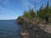
Aside from the planning, of counting ounces and experimenting with food and questioning my route, I still get a thrill of excitement everytime I think of this trip. I'm going to Isle Royale, back to Michigan and its green trees and Lake Superior and well-worn mountains, and I can't wait. Arizona can keep its dry heat. Even if this trip ends up being a cold march through one rainy day after another, I'll be back in the Upper Peninsula, and that's all that matters.

-
Jacob Emerick
Aug 13, '15
Thanks sir, and thanks for linking to that! It was vaguely familiar, but I didn't remember all of it for sure, and it is a fantastic (and sobering) read. At least the tail end started to brighten up a bit... Everything in the first half though, wow.I definitely appreciate the caution. Right now I have two different bail points - if things are looking rough after the first two days I can turn around at Hatchet Lake and skip almost all of Minong, and if things look bad after four days I can turn back on Greenstone. The first option shaves off a cool hundred miles and the second around forty. My only fear is that I get five or six days on before realizing that I bit off more than I can chew. Then my only hope is to hop on the Voyager to get back to Rock Harbor.My favorite part of your adventure was on your way back to Houghton and you decided to return to re-tackle the Isle. Any idea when that return will be?
-
nailhed
Aug 14, '15
Well, i was *supposed* to return in 2013....then 2014....etc.The holdups have been that i was unable to coordinate with the buddy/s i wanted to go with, then i was working and that got in the way...as it stands right now i might get enough vacation time to get there next summer, but we'll see.
-
Jacob Emerick
Aug 14, '15
Oh man, that's too bad that things keep getting delayed. At least with a buddy you'll have someone to talk to besides the carvings in the shelter, eh?Do you think you'll focus on bushwhacking to mines on your next trip? One area that looks really interesting is Blake Point, a healthy haul along the shoreline (or canoe through Tobin Harbor), but I'm not sure if there are any mines out there. It kinda follows the Ultima Thule concept... kinda, as it's the northeastern point and (may) have a good view of Passage Island.
-
nailhed
Aug 17, '15
Actually i would like to try & get a good overview of the isle by taking the ferry around it and getting off at various points to explore. i'd also really like to get to Amygdaloid Island
-
Jacob Emerick
Aug 21, '15
Oh nice, that would be a great way to see things. And the Amygdaloid area looks awesome. Do you know if the ferry stops at Crystal Cove or would you have to get a kayak?
-
matt mooney
Aug 24, '15
Jacob,Good luck, be safe and have fun getting back into the woods.Matt
-
Jacob Emerick
Aug 24, '15
Thanks Matt! I can't wait, even with the forecast coming out as a bit warm and humid. Will be great to see the lake again.
-
nailhed
Aug 24, '15
I believe the ferry does indeed stop at Amydaloid, either that or its their smaller boat, perhaps the MV Sandy
-
Jacob Emerick
Aug 28, '15
Got it. The MV Sandy does make sense - though it'd be interesting to know how long they'd be willing to wait around for day hikers.
-
nailhed
Aug 28, '15
I think they just drop you off and make the rounds at regular intervals.
Add to this discussion