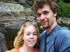
Katie and I at Mulligan
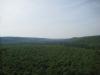
It's no secret - I really like Mulligan Plains. This remote section of Marquette County is off the beaten path and contains many hiking adventures, including waterfalls, cliffs, and lakes. So when Katie and I headed up north on a cool fall day before hunting season I made it a point to take her to Mulligan and show her one of my favorite Upper Peninsula destinations.
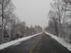
Even though we slept in at the Ishpeming hotel quite a bit, we managed to make it to the creek before noon. The easiest place to visit at Mulligan are the falls north of Silver Lake Basin, so we took the county roads up along the western edge of the plains and parked at the foot bridge over Mulligan Creek. Faith and I had visited this area a year ago and had taken a convoluted route to the falls that involved crossing the creek over a beaver dam and bushwhacking through some terribly thick pine trees. A four-wheeler had given us this route before, but I didn't want to follow it today.
Katie and I crossed the narrow, shaky bridge over the creek and headed up the narrow two-track. Instead of cutting across the creek, like I did last time, we cut off the trail (which bends northwards) and continued along the side of the creek. The trees weren't thick on this side of the creek, but we did have to go up and down two tiny creeks that flowed from the north. Barely trickling at this time of year, they still managed to cut a deep valley in the sandy soil.
After crossing the first creek I was surprised to see a hunting cabin ahead of us. We approached it carefully, since hunters like to start early in this area, but found no sign of anyone nearby. The cabin was perched above Mulligan Creek and we could hear, but not see, the falls a short distance away. A footpath led from the cabin to the falls. While our route was much shorter this way and involved very little bushwhacking (none if we would have stayed on the two-track), the four-wheeler gave us the tougher set of directions to avoid trespassing. Unfortunately, it appears that the only legal way to reach the falls is the difficult southern bank.
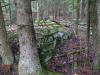
We headed down the narrow footpath through the second small creek, passing by some impressive rock outcroppings rising up to the west, and made it to Mulligan Falls easily. Since the undergrowth is thick around the creek we didn't travel too far upstream, only seeing the first set of falls in the narrow canyon. Katie enjoyed the area quite a bit, with the open, mossy rock slabs and towering tees, so we took our time and rested a bit by the riverside. I decided to climb up a few of the northern rock outcroppings. Some of these outcroppings might offer a limited view upstream of the creek, though the high trees and hills would limit it.
Since we had already walked past the hunting camp once, we returned to the cabin and took its two-track out. This path took us north quite a distance, bypassing the deep section of the first small creek, before meeting up with our original trail that took us back to the bridge. Along the way we saw the remains of a field dressing and heard a few gunshots. Didn't see any hunters or four-wheelers, since most of them were probably a few miles further up the trails, but we also didn't waste any time getting back to the car.
Trails to Mulligan Falls
It was early afternoon by the time we drove out of Mulligan Plains. I was glad that I had finally taken Katie to see this area, even if it was only to see the first set of falls. While the fall is the best time of year to visit the plains, it was a bit stressful to know that hunters were out there weeks before the season started.
Comments (0)