A Few River Gorges
The Western Upper Peninsula has a unique geology compared to the rest of Michigan. Ancient bedrock creates surprisingly tall mountains and highlands that trap lakes, swamps, and wetlands hundreds of feet above Lake Superior. Throughout the geologic history of the area, glacial and volcanic events have both carved deep channels and helped confine the waters, eventually leading to rivers draining the land through gorges and over waterfalls. Here is a short list of the major gorges of the area, at least the ones I've had the opportunity of visiting.
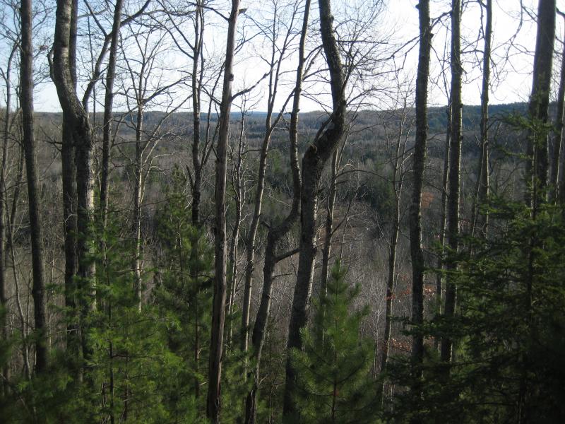
Looking across Sturgeon River gorge
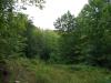
Sturgeon River cuts one of the more well-known gorges of this area through the flat, sandy Baraga Plains southwest of L'Anse. This gorge is heavily forested, and good lookouts over it are hard to find. The two highlights of this area include Silver Mountain, an ancient volcanic plug, and Sturgeon River Falls, both located in the Ottawa National Forest. Most of the gorge is simply a deep river valley (three hundred feet near the falls), though there are a few rock cliffs downstream of the falls. The Sturgeon River is a powerful river and cuts another deep channel through slate rock at Canyon River Falls near Alberta.
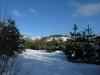
West and south of the Sturgeon River lays the huge watershed of the Ontonagon River. There are many gorges along its branches and tributaries thanks to the sandy soil and sandstone bedrock. Most of the river's branches are in deep river valleys, but there are a few rocky gorges. I have been to the Onion Creek mouth, a remote set of waterfalls in a cluttered setting, as well as the breathtaking canyon near the Victoria Dam. Both of these are located in sandstone gorges.
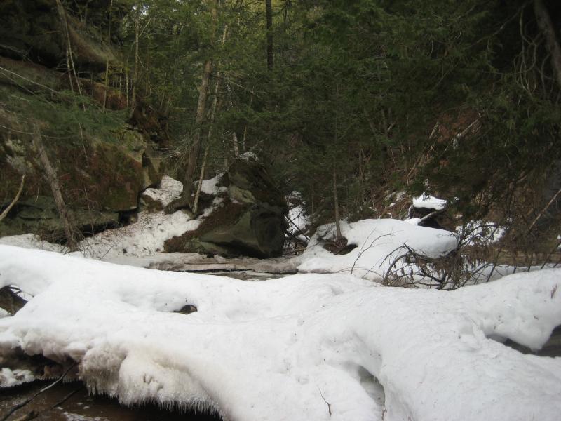
Snowy sandstone Onion Creek gorge
North of the Portage lies a number of creeks that flow off of Brockway Ridge to Lake Superior, some falling over six hundred feet. Most of these creeks cut deep cuts into the conglomerate or sandstone rocks, even with minimal normal flow. The most impressive ones include Hammel Creek (Douglass Houghton Falls), Dover Creek (Hungarian Falls), Jacob's Creek, and Silver River.
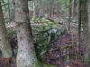
The Huron Mountain area has plenty of deep river gorges. Both branches of the Huron River go through a gorge, with the West Branch having a series of incredible waterfalls along its route. These gorges have a unique rock structure visible along their steep walls, with angled and blocky chunks of loose walk towering dozens of feet above the rivers. Further to the west of the Huron River is the deep, sharp Slate River gorge with four named drops within. This gorge is lined with angled slate rock and sharp rock outcroppings. These three gorges are surrounded by tall pines and hardwoods and, with the exception of the West Branch of Huron River, far from cabins or any signs of civilization.
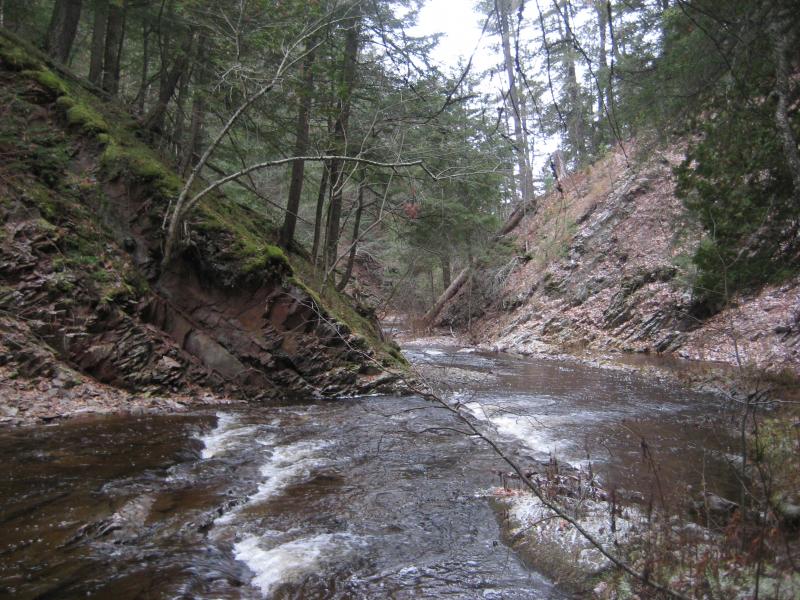
Slate River gorge
A few more river gorges in the Huron Mountains area include the mouth of Cliff River (a sharp, volcanic canyon with a narrow swamp below) near Mt Benison. The Dead River cuts a deep canyon into solid volcanic rock near the McClure Dam with several straight cliffs over fifty feet high. Other notables include the Little Garlic and Carp Rivers near Marquette.
-
Jacob Emerick
Dec 2, '09
Alder Falls is pretty sweet, with the drops nestled in between those great big ol' outcroppings. Silver River is pretty neat - I visited the upper falls once in the dead of winter, with no foliage to block the view, and it carves a pretty decent valley below the largest drop. You should really check out the Slate River Gorge by Skanee if you're not worried about wading in water, though. Onion Creek is pretty neat, but the water barely trickles over the sandstone. Where else by Big Bay have you been to?
-
Joel Schuett
Dec 2, '09
I have hiked through the Slate River Gorge once before- from Skanee Rd. to "Kuckuk's Falls"; in the river on the way out, and along the trail at the top of the northern canyon wall on the way back! You are right, this is another beautiful area and a great hike for a hot day! As for Big Bay, I haven't been all over out there, but I have been to a few cool places: the Yellow Dog River along the series of waterfalls off County Rd. 510 and Pinnacle Falls off Triple A Road, Big Pup Creek Falls, Thomas Rock AKA Gobbler's Knob off 510, Weeping Rock AKA Triple A Rock/Wall and the various rock knobs and peaks in the immediate vacinity of Weeping Rock off Triple A Rd. (Are these the Panorama Hills that I have heard about?? If not, the name sure would be fitting because although the knobs are not particularly high some of the less-wooded ones have some incredible panoramic views of the area!!) I have also been out to the summit of Hogback Mt. nearer to Marquette and, of course, Alder Falls and Gorge. By the way, did you know that there is actually a 5th fall along Alder Creek?? In addition to the four you mention on your waterfall site, there is an approximately 12 ft. plunge waterfall immediately upstream in the gorge from that last fall you mention. It is easy to miss, and there is no way to get a good picture because it is an underground waterfall!! There is a hole in the creek bed, probably just big enough that I could squeeze through, that opens into a small room/cavern and the water simply flows into the hole and drops about 12 feet to the bottom. The water must then rejoin Alder Creek somewhere downstream via a spring or something....like I said not much to see but it does make a pretty loud roar!! I would LOVE to one day visit the Huron Mountain Club (although I won't hold my breath waiting for that), and would also like to hike the lakeshore north of Big Bay out to the Black Rocks!
-
Jacob Emerick
Dec 5, '09
Think you got me beat for exploring around Big Bay - I haven't been to Gobbler's Knob or Weeping Rock. Can't help you out with Panorama Hills or Black Rocks, but they both sound like some pretty sweet locations! How far have you been down Yellow Dog Falls? I noticed the trail dies after the third drop, and I ended up doing some serious bushwhacking to visit the lower four and Bushy Creek. Thanks for the Alder Falls tips, I'll have to check that out as well. As for Huron Mountain Club... I think I wandered on their property a few times on accident near Cedar Creek, but there's a lot of awesome sights into their property that you can get along Blind 35, near Dodge City, and the Western Huron Mountain Peaks (Bald Mountain, etc). To stand on the shores of Mountain Lake and see the mountains rise from the shoreline would be amazing, but I'm not about to hike a mile onto private land and risk some hefty fines to do so.
-
Joel Schuett
Dec 8, '09
Gobbler's Knob is a short trail off 510 just a bit west of 550. It is the first two-track west of a big clear cut area for a radio tower. It is an overlook with a view of Big Bay, Lake Independence and Lake Superior. I was there once, and there were quite a few locals coming and going. Weeping Rock and other various rock knobs are located in the area bordered by AAA on the south, Blind 35 on the east/north, and Snake Creek to the west. I access the area from AAA. Students at NMU do some rock climbing at Weeping Rock, and there are other scattered rock knobs in a vacinity, some having nice views of the surrounding area and some being mostly forested.I have been to the main Yellow Dog Falls (the first one downstream from the 510 bridge), missed the next one downstream, saw the next 4 in the series, and missed the last one and did not make it to Bushy Creek. I'm going to have to go back and walk the entire series!
-
Jacob Emerick
Dec 10, '09
I'm definitely going to have check Gobbler's Knob - I must have driven past that spot a dozen times last year. Those rock knobs sound interesting - any of them give a good view of the Yellow Dog Plains?
-
Joel Schuett
Dec 11, '09
I'm not sure just exactly *what* you are looking at while at the top of some of these knobs. If I had to describe the area, I would call it the "foothills" of the Huron Mtns. interspersed throughout a flatter/lower area that is reminiscent of the Yellow Dog Plains. If I remember correctly, the soil is fairly sandy here as well. This is another area where an ATV would come in handy, because the knobs are pretty spread out over wide area. It would be an easy walk because logging roads seem to lead out to all the various knobs, but a lot of time would be wasted walking from knob to knob. A regular 4WD vehicle could drive these roads without much problem, but one would have to find another route in (possibly off Blind 35) other than the one I use to enter the area because there was a tree down in a rough section of the path by Weeping Rock the last time I accessed the area via AAA.
-
Joel Schuett
Dec 11, '09
I also noticed that two geocaches have recently been placed in the area. On geocaching.com, search for geocache ID GC200QB titled "Huron Mountain View". The cache site is a really low rock knob that is an easy, quick climb just off the trail. I call it the "Central Knob". It gets you JUST above the tree-line and offers outstanding 360 degree panoramic views of the area. The photograph in the geocache entry shows another nearby knob which seems to be the tallest in the immediate vicinity. I call this one "Lookout Peak" and the views from the summit of the high, steep peak are really impressive!! There was little to no evidence of human activity up there, other than a super old, overgrown logging trail and some equally old large stumps. The other new geocache is GC200PX and is titled "Rock Climber". This geocache is located at Weeping Rock, and one of the pictures is a good shot of one of the cliff walls. Weeping Rock is mostly forested on top, but does offer some limited views of another nearby knob off to the immediate west. This is the large hill that appears straight ahead as you travel AAA just a mile or two west of 510 where AAA curves to the left. This other knob I call "Falling Rock" because of an absolutely HUGE piece of rock that broke off the side at some point and now lies perched down towards the base of the knob. I have not explored this knob, only driven by it, but it looks pretty heavily forested as well. There are also long, bluff-type knobs surrounding this area in the distance, but I have not been to any of them (the ones to the north may be in Huron Mountain Club property, however I am not sure about that!!)
-
Jacob Emerick
Dec 12, '09
Sounds like an interesting area. I've been to the north, on the hills of Blind 35 (which may be the surrounding bluffs), been haven't heard or visited any of these places. Blind 35 hills did offer some sweet views, even had the potential of looking down the Salmon Trout and over to Conway Lake, but I turned back early with the setting sun. This is one area, with the knobs and old highway, that might offer some awesome views of the Club property without trespassing - the other is above Hogback Falls. These knobs are on the list now... Thanks for pointing them out! Also, I was searching for a while for a good spot to view the Yellow Dog Plains and Huron Mountains in a single sweep. Most of the mountains are shorter then the plains, so it's been fruitless so far. Maybe Lookout Peak will give me better luck.
-
Joel Schuett
Dec 15, '09
I've never been along Blind 35, I will definitely have to check it out! Does it go all the way to the Salmon Trout River, or is it gated or posted before then??
-
Jacob Emerick
Dec 18, '09
It looks like it goes all the way to the river, but I strongly doubt that it has open access. One of the huge hurdles of my waterfall hunting was the falls along Salmon Trout River, which are supposed to be amazing. Only one (Hogback) is not on their property, and this road leads directly to the middle falls. Since there are no pictures or evidence of the falls online outside of vague references, I'm assuming that the road is blocked off and/or closely watched to deter random visitors. I only made it a mile or so down the road before chickening out... It's in nasty shape. There are some some sweet outcroppings south of the road that might be worth checking out, and the north ones are pretty nice too (and on the border of their property)!
Add to this discussion-
Jacob Emerick
Dec 5, '09
I have been along the lower canyon, though I'm pretty sure it's on Club Property. The gorge was very deep and sudden, looking like it was carved by glaciers or volcanic action rather then the river, and Cliff River was just a small, meandering creek at the bottom. I took a huge circular route up Cedar Creek to Cliff River (though we didn't go all the way to Mountain Lake, cutting up the hill in between) and followed Cliff River upstream to the falls. Found a small drop below Cliff Lake, but nothing near the mark on the map. We might have missed a small drop, as we took a few shortcuts around the river's bends (there was two to three feet of snow on the ground), but we did visit the mark you mentioned and found nothing but swamp. There might be something downstream, but not large enough for us to easily hear. 40 ft Falls is a nice spot, though. Been to Cliff Lake?
-
Joel Schuett
Dec 8, '09
Man, that sounds like a great hike along Cedar Creek and back along the Cliff River!! I would like to see that canyon at the Cliff River's mouth, but if it is on Club property, I may have to re-think that!! Thanks for the info on that second waterfall marked on the topo maps, I wonder why they sometimes note small falls on their maps, but then make absolutely no mention of other, much larger, drops?I have never been to Cliff Lake, although I have seen it from a distance from a large cliff in the western Huron Mountains. It is the large rock outcropping just to the immediate east of Tick Mountain with the tall, sheer cliffs along the west and south sides. We informally refer to it as "Cliff Mountain". It looks like Cliff Lake would be a pretty nice area being nestled in a valley between all those mountains!! 40 Foot Falls is pretty much the closest I have been to the lake.
-
Jacob Emerick
Dec 10, '09
It was a heck of a hike - had three friends and no snowshoes. We were dragging more then a bit after the eight miles. The views were fantastic, though, especially from the top edge of that gorge. Oh, and I completely agree with you on the waterfalls thing. There are dozens of unmarked drops with only local names (all of the Dead River Falls) and other marked drops that are tiny (if they are even there). Awesome on the Tick Mountain! I loved climbing those rocky outcroppings, though I got stuck in a nasty thunderstorm near the benchmark to the north. Haven't seen Cliff Lake yet either, but hoping to approach it from the northwest some day. The two mountains there I haven't done yet are Raven's Nest (a north-facing cliff) and Mt Benison (which isn't on Huron Mountain Club) - have you tried either one yet?
-
Joel Schuett
Dec 10, '09
I have been to the Raven's Nest (AKA Toiletbowl Mtn.) but not Mt. Benison. We parked on the "main road" and hiked the trail up to Raven's Nest. The views are great, being so close to the lake shore, but slightly obscured by large pines. In my mind, it is not a true "summit", more like an opening in the trees at the top of a bluff! Superior Mountain (where the benchmark is) is another awesome place! That location is actually a triangulation station, and there are three benchmarks to look for: SUPER, SUPER 1, and SUPER 2. All three are still there although one of them has been pried on... As we left the summit of Superior Mtn. (we had ATV'd to the top), we noticed that the trail actually forked up towards the top. We decided to see if there was an alternate route up/down that we could use, so we took the other fork in the trail. It was an extremely rough, rocky trail down- very similar to the regular path everyone uses to get to the summit. Down, down, down we went finally popping out onto a level logging road somewhere along the east side of the mountain. Neither one of us had any idea where we were, but we had our GPS so we continued on. We kept on the road heading north, passing right along-side large rock knobs we had never seen before, paralleling a large long mountain range on our right-hand side (which I now think was Mt. Benison). At the time I was totally confused and was thinking it was Bald Mtn!! Finally we made a right-hand turn at an intersection and...........ran smack into two Huron Mountain Club security guards in an SUV. Turns out we had wandered onto Club property!! We explained that we were totally lost, and they were really cool about it. We chatted for about 15 minutes, then turned around and headed back the way we came, back to the top of the mountain. I am not sure if it's possible to access Mt. Benison without trespassing on HMC property- I have to get a current plat book for Marquette County to figure that out!
-
Jacob Emerick
Dec 12, '09
Nice story! I've always been paranoid of bumping into security guards while wandering around those mountains, especially after some of the horrors that locals will tell about fines and whatnot. It would be kinda nice to talk to one just to figure out where the property lines are, as I can't find anything online or on topo maps (though a plat map would probably do it). I'll have to re-climb Superior now to find those benchmarks - probably walked right past them. Mount Benison, to the best of my knowledge, is not on Club property, though it is part of a nature preserve. The easiest route would be to follow Little Huron River upstream, veering to the right after it bends back up to the north. Huron Mountain Club owns a good chunk of the shoreline to the north of the mountain, including the area around Howe Lake (which is probably near where you were driving), but you could avoid their property be cutting in from the south or east. I'm not sure what sort of regulations are in place for the preserve or if guards will patrol out that far, but it is just north of Cliff Lake and several hunting camps, so I can't imagine it being too strict about hikers.
-
Joel Schuett
Dec 15, '09
Yeah, we asked the guards just where *exactly* we had crossed onto HMC property, and they tried to explain, but it was the usual "well, when you turned at the big hemlock grove, and passed a small washed out sandy area",...etc. Not being locals, we didn't know what they were talking about, and they couldn't describe it any better! I looked at Marquette Co. plat books online, but they are still selling the 2006 version!! Talk about out of date info! The walk following Little Huron to Mt. Benison would be a fun one! I always enjoy walking water courses, because you don't have the worry of getting lost unless you wander away from the stream or river you had been following...
-
Jacob Emerick
Dec 18, '09
Totally agree on the watercourses - plus, you never know what kind of cool little drop or rock formations you'll find along a tiny woodland creek.
Add to this discussion