Silver River
While many people will claim to know of Silver River it's difficult to know which river they are talking about. After all, there are three Silver Rivers within fifty miles of Houghton, MI; one in the Keweenaw near Eagle Harbor, one near West Branch Sturgeon River near Alston, and the third one in Baraga County. The third one is the largest and, in my opinion, the most impressive in terms of both waterfalls in area.
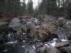
Primary route of Silver River
Silver River, in Baraga County, does not flow by any population centers or industrial sites. It is not dammed along its route, and besides the bridges that span it and a scattering of houses and cabins along its route, is untouched by man. From headwaters in swamps within the Craig Lake State Park, the pristine waters fall eight hundred feet before emptying into Lake Superior's Huron Bay.
There are two main branches near the head of Silver River. The larger branch drains some lakes and swamps southeast of Herman, MI. After passing the dead end of Lahti Road, this branch drops three hundred feet over five large waterfalls, collectively called Upper Silver Falls, and numerous rapids. This stretch is normally quite dry during the year, with the falls flowing best immediately after the spring melt. East Branch Silver River drains a rugged area north of Mt Carwood and meets with the main river near Silver Road, but is mostly sluggish with no significant drop.
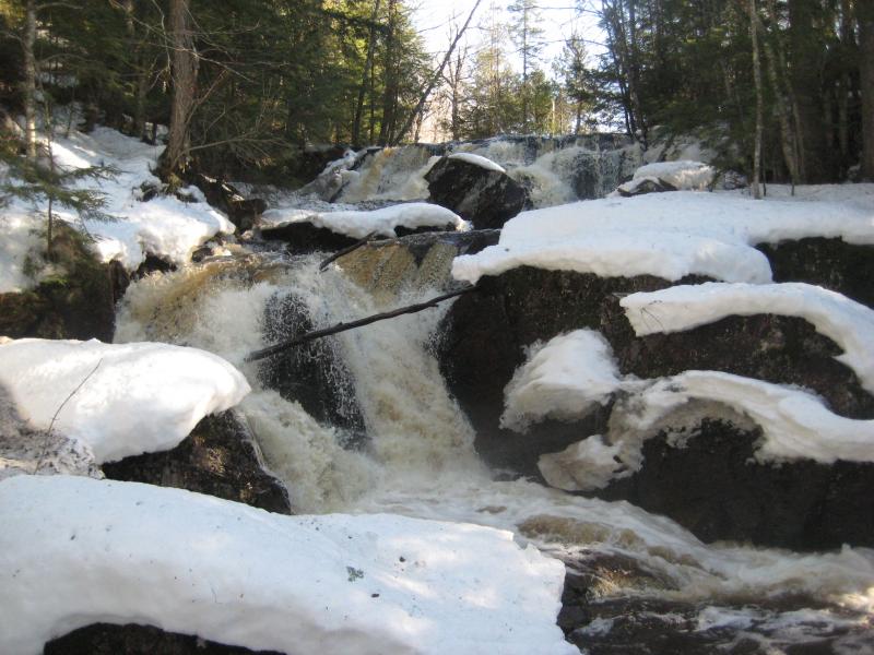
Upper Silver Falls
After the two branches meet, Silver River crosses under the Silver Road bridge a much larger stream. Between this bridge and the Arvon Road bridge, a distance of about two miles, the river drops an additional three hundred feet over several dozen individual waterfalls. Unfortunately, this portion of Silver River has a number of residences and cabins, making visiting these drops difficult. Kayakers often run this stretch of river during the spring, so more details on this stretch and images can be found on different white water blogs and websites.
After crossing under Arvon Road and passing a large gravel pit to the east, Silver River passes over two more sets of waterfalls before mellowing out for several miles into a slow, winding path. There is one more set of three waterfalls at a roadside park off of Skanee Road, well known by locals as Lower Silver Falls or just Silver Falls, before it empties into Huron Bay. Fisherman can be found along the last several miles of the river, but the steep chutes and falls at the lower falls make it difficult for fish to swim any farther upstream.
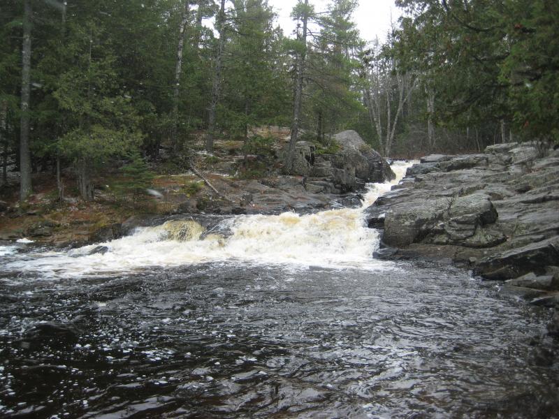
Lower Silver Falls
Whether it's fishing, hiking, kayaking, or just visiting, the pristine waters of Silver River make for an excellent stop. To visit the upper reaches, take Lystila Road to Lahti Road eastwards out of Herman. Stay straight on the two-track when the main road turns ninety degrees to the right. The first fork on the two-track leads to the main waterfall while the second leads to the uppermost drop. The easiest way to visit the middle stretch is by parking near the Arvon Road Bridge over Silver River, located off of Dynamite Hill Road by L'Anse, and either hiking upstream or downstream. A DNR sign on Skanee Road six miles out of L'Anse points to the lower falls.
-
Jacob Emerick
Dec 10, '09
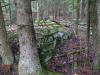
You're right on drops between Silver Road and Arvon Road. I was wandering along the river during the spring and saw two landowners. The first one waved and was pretty friendly but the second guy thought I was going to break into his cabin. After yelling a bit at me he followed me back out to my car. First time I met an angry landowner - think that he'd have signs up if he was that worried! Especially since white-water guys are always cruising down that stretch right past his house... Oh, and the falls site is horribly out of date. Been trying to finish it/fix the old information, but lots on the plate and whatnot. Thanks for the info about the railroad grade - mind if I include it? And I'd bet they didn't remove it because of the rocks in the area, but that's just a guess. Too hard and not worth the effort to break the concrete loose. Have you seen the rock wall on the east side of the lower falls? Might be the remains of the old road out to Skanee...
-
Joel Schuett
Dec 10, '09
That's crazy about the irate landowner along the Silver River! Like you said, if he's that worried why didn't he have his property posted?? Feel free to use the info about the RR grade, I thought it was pretty interesting myself!! I can appreciate that spot even more knowing it's history, know what I mean?? You can actually drive the RR grade most of the way to the river. Turn north onto Pinery Rd. from Dynamite Hill Rd. and basically take it straight to the end. There is one intersection with Third Lake Rd. (or Indian Cemetery Rd.) where you go straight, there are some other logging roads that split off, but the route is pretty obvious. Maybe 3/4 of a mile south of the river, the trees and vegetation close in on the path and a car could not get through without getting REALLY scratched up. From there it is an easy hike up the RR grade, or an ATV could make it all the way to the river. Besides the bridge abutments at the river, there are a couple of areas on the grade where the railroad ties are still barely visible in the ground and you can feel the roughness as you go over them!! Also, you can see where the grade was built up to a nice level path as it travels through some of the low swampy areas!! I didn't see the rock wall at the lower falls, where is it, by the falls or downstream from it?? I would like to check that out the next time I make it to the area!!
-
Jacob Emerick
Dec 13, '09
Interesting about the grade - I usually just stop at the small park near the lower falls and hike upstream. There's some other things in that area I do want to check out, like Pinery Lakes and the old cemetery, so I'll prolly end up meandering up that way. The rock wall is directly across the upper chute by the parking lot. Not big, but findable. Think it's from the old bridge over the river (you can see it from postcards and whatnot), but it's pretty small.
-
Jacob Emerick
Dec 14, '09
Random question about the grade - I was reading the Wikipedia entry for Blind 35 and saw a mention of a railroad from L'Anse to Cliff River. I know that this one isn't it, but have you heard anything about 'Ford Railroad'. Skanee Road and the two-track south of Tick Mountain are awfully straight, but I don't know if the tracks went to Cliff River or Cliff Lake.
-
Joel Schuett
Dec 15, '09
As far as I can tell, there were three main branches of the Ford RR, all entering L'Anse(along the same track) from the east along Dynamite Hill Rd. The southern branch ran east roughly along Dynamite Hill Rd, curving south with Indian Road, passing between Laughs/Lost Lake and Indian Rd., then cutting SE towards the Silver River. The main line ran east along Dynamite Hill Rd., then turned NE, following Arvon Rd. for a little while, before cutting N/NE up towards Bella Lake. Leveling out and traveling due east, it passed south of Bella Lake, crossing the Slate River on the bridge between the Quartzite & Black Slate Falls. After crossing the river, the RR followed the left road fork, then curved E/NE. The "Sensenbrenner Trail" follows a large stretch of the grade here, crossing Fossom Creek. Sensenbrenner Trail dead ends here into Greenhouse Rd.; However, the RR used to continue on due east, crossing the West Branch Huron River, Robarge Creek, and the East Branch Huron River. There may be bridge remains at the West Branch Huron River crossing, I still have to investigate that!! The RR continued basically due east paralleling just to the south of Big Bay Rd. I lose where it used to go just as it gets to where the Cliff River Rd. intersects with Big Bay Rd....Finally, the northern branch of the Ford RR is the one that crossed the Silver River upstream of the Lower Silver Falls connecting the main RR along Dynamite Hill Rd. with the old Hebard RR in Pequaming that Ford had recently purchased. Check the topo map on the Acme Mapper, it shows you the course of these three RR grades. (They are shown with a dotted line reading "Old Railroad Grade")
-
Jacob Emerick
Dec 18, '09
Wow, I was really looking in the wrong direction. I assumed the tracks ran over Big Erick's Bridge to Cliff Lake. I see exactly what you mean now, thanks for pointing it out! Interesting - I wonder when these were built. It sounds like one of goals of the IR&HB was to run by the Arvon Slate Quarry, but these tracks would have run right past the quarry. I've never heard of the Sensenbrenner Trail - snowmobiler term? Speaking of that area of West Branch Huron River, have you been to West Branch Huron River Falls?
-
Joel Schuett
Dec 20, '09
I've never been to the West Branch Falls; I've never been sure how to approach them with that one road paralleling the river being posted "No Trespassing". They look really impressive, though, and something I definitely want to check out! It might be nice to walk downstream from the Black Creek Rd. bridge to the West Branch Falls, I could also check for Ford RR bridge abutments along the way... According to The Railroad That Never Ran, the IR&HB ran right along the Slate River past the quarries, cutting between the quarry on the east side, and the other on the west. It then joined Arvon Rd, and headed straight out to Huron Bay. The "Sensenbrenner Trail" is just a path that follows a part of the Ford RR grade, starting south of Roland Lake and traveling straight east to Greenhouse Rd. It was under alot of water when we ATV'd through. Maybe just a locally-given name for the path??
-
Jacob Emerick
Dec 21, '09
I'm not sure if it's possible to approach from the north, though you'd pass by a bunch of drops on the way. There were several cabins upstream of the falls that you'd have to walk past. There's a rough trail that follows the river from the south after a two-track fords the river. This trail was well-trod and stayed deep in the gorge, so I'm assuming it's the primary way to get to the falls. I've never been to the Slate Quarries - that info just makes me want to visit it even more! Also, based on the old Ford RR grade, it looks like the clearing on the Northwestern Road where the trail to the Cliff Falls Hunting Club cuts north could be the site of the old logging camp on Cliff River. Wonder if there's anything left hiding in the pines there...
-
Joel Schuett
Dec 23, '09
The slate quarries are a real fun place to explore. I would recommend parking along the Slate River right where Arvon Rd. makes a hard right-hand turn and curves away from the river. Cross the river from where you parked, and hike upstream. When you get to the eastern quarry (you will know when you get there), cut away from the river and do some exploring. Make sure you don't miss the idyllic little quarry pond tucked away in the forest!! This is my favorite spot out of all the different cool spots at the quarries!! This eastern quarry seems to be basically forgotten, I don't think many people know it is there! There are no roads or paths into this one. After you're done here, cut back to the river, and keep going upstream, very soon you will come to a big slate pile on the west bank. I have not really checked this pile out closely, and do not know where it's associated pit is located. Keep going upstream, and you will encounter two very large (15-20 ft. high) stacked piles of slate, one on each side of the river. My guess is there used to be a bridge here during the quarrying days. Somewhere around here ( I can't remember if it is up or down-stream from the stacks) on the western side, there is a small spot I call the "swimming pool". It is a spot where it is evident rock was blasted out (the walls of the pool are sheer up and down), but they only went about 3 or 4 feet down. It is flooded, but you can see it is not deep at all. I don't know if it was used by the townspeople for some purpose, or if it was the beginnings of another pit that was quickly flooded or abandonded. Continuing upstream from the stacked slate piles, after a bit you will come to a massive pile of slate on the western bank. This is the main quarry area that everyone visits. I have counted two flooded pits here, along with piles of slate everywhere. Scattered here and there are more stacked slate piles, you just have to keep your eyes open to see them!
-
Joel Schuett
Dec 23, '09
Regarding West Branch Falls, is the 2-track you mentioned that fords the river the path that eventually leads to Big Falls?? If so, I know what path you're talking about! Also, on the Slate River, the stretch between the two quarry locations is flat-water but starting at the main quarry and continuing upstream are more Black Slate Falls-type drops. I haven't been any farther upstream than the main quarry, so I don't know how long this stretch of drops is...
-
Joel Schuett
Dec 23, '09
Finally, regarding the Ford RR/logging camps, there were several scattered along the route (Cliff River, Erickson, & Eliason off the top of my head) and I have also wondered what might still be found!! It would be fun to hike certain portions of the old grade and just poke around in the woods along the way. I am sure there are interesting things to be found!!
-
Jacob Emerick
Dec 27, '09
Thank you for the detailed description on the quarries - I'll definitely have to check this area out when I'm around Arvon next. Interesting on the drops... I'm kinda curious if there's another Quartzite-size drop far upstream now. Yes on the road - I usually just park on the eastern bank and follow the river upstream. It's easier to park on the west side, but the trail hugs the eastern bank all the way to the lowermost drop. Definitely agree on the logging camps as well... Wonder if there's anything left on the Tama Siding Line or at the old town of Arvon?
-
Joel Schuett
Dec 29, '09
I haven't hiked upstream from the main quarries, so I don't know what you could find or how long the series of falls stretches.. It would be another nice hike along this stretch of the river though.. I haven't found anything as far as foundations at the old site of Arvon, although I've read that they exist..This summer I found a big rusty metal circle that I'm guessing was once part of a wagon wheel in the Slate River, but that's about it- other than all the slate and the flooded pits! Thanks for the info on the West Branch Falls, I'm definitely going to check them out the next time I'm up there (hopefully this spring)!
-
Jacob Emerick
Dec 29, '09
It does look like there are some interesting drops upstream of the quarries... Right along the railroad grade, too. Looks like a good hike for the spring! Looks like Arvon is a bit easier to get to then I thought. Half expected it to be hidden south of the quarries.
-
Joel Schuett
Jan 1, '10
Yeah, I've wanted to travel upstream from the quarries, myself. There's always too many things to do and not nearly enough time to do them all!! I think the town of Arvon was basically right off the sharp turn where Arvon Rd. curves to the west after paralleling the river bank, where the overgrown orchard is...
Add to this discussion-
Jacob Emerick
Dec 10, '09
Awesome find! I've only driven through this area, never really stopped and wandered. Assuming that you were in this area... http://mapper.acme.com/?ll=46.73330,-88.25489. I'll have to check it out. How is Curwood, anyways? Arvon doesn't sound worth climbing (except for a few possible south-facing views), but there's no information out there on hiking or sights off of Curwood. Speaking of upstream falls, I'd bet there's a ton of drops upstream on Ravine, Huron, and Slate Rivers around the same general area. Probably more fit to explore on ATV then foot with all the logging trails.
-
Joel Schuett
Dec 10, '09
That location on the Acme Mapper is pretty close. I don't know how to do the link, but I think the coordinates are N46 43.505/W88 16.895. I didn't think to check the GPS at the time we were there, but I'm pretty sure this is the spot where we found the waterfall! We had ATV'd from Celotex Rd., up the Durchman Lake Road (which is an awesome swampy/rocky path a car could not make it down), to where it dead ends into the trail from Silver Rd. to Mt. Curwood. Then out to the Silver Road. Mount Curwood is just like Mt. Arvon, completely wooded with no views. It is not distinctive when you are in the area; the entire surrounding area is highlands, and Mt. Curwood just happens to be the highest knob in an already elevated area. While Curwood, itself, is not that impressive, the surrounding areas are scenic highlands with up-land lakes, marshes, and streams draining down into the surrounding rivers (Silver and Peshekee). I would definitely agree that an ATV would be handy in exploring all these various headwater streams, many of them seem to be buried in the middle of hundreds of acres of timber company land!!
-
Jacob Emerick
Dec 13, '09
That spot does look promising for a drop. Might be an interesting hike just to park on Silver Road and make an odd loop around Curwood, seeking out all the woodland drops to both the Peshekee and Silver River. Does Durchman = Dirkman Lake? That also looks like a neat place to visit. I made it down Celotex Road with my car ones all the way to Clear Lake, but was turned around at the gate there. Never tried to head north to Dirkman/Durchman or Curwood... On the Arvon topic, I think this guy might have found a view (and provided the location of it on his map)... http://sgowtham.net/showcase/2009/06/12/17/59/14/mount-arvon.
-
Joel Schuett
Dec 13, '09
Another spot I want to check for waterfalls is N46 42.295/W88 18.541. Several contour lines come close together here around the bend and directly upstream, suggesting a potentially decent sized drop. This stream empties from the western Durchman/Dirkman Lake, so the potential exists here for better water flow versus some of the other tributaries that strictly drain swamps and springs. Speaking of the Durchman/Dirkman Lakes, I have seen it spelled both ways, and don't know which is correct! You could make it from Silver Rd. to Mt. Curwood in a regular vehicle, but heading south at the turn onto the Dirkman Lake Rd., you wouldn't make it far...Heading north on the Dirkman Lake Rd. from Celotex Rd., you could make it a little way up, but still not to the Lakes (the trail passes between the two, which are visible through the trees). It would definitely be a fun trail to hike, and your idea of hiking a loop circling around the area would be sweet!!
-
Joel Schuett
Dec 13, '09
One more thing! If you try to head up Dirkman Lake Rd. from Celotex Rd., you make the left (North) onto Dirkman from Celotex, and follow the main path for a while. After a bit, the road will parallel the side of a swamp on the right, then curve to the right and go over a small wooden bridge at the head of the swamp. If you reach this point you've gone too far (up ahead are multiple branches of dead-end logging roads)!! Turn around and re-trace your path paralleling the side of the swamp. Once you get just past the swamp, take the path to your left--this will lead you to the Dirkman Lakes; however, I don't think a regular vehicle will make it much further north.
-
Jacob Emerick
Dec 14, '09
Yeah, looking at those roads coming from the south is a bit scary. The one time I got my little Ford Taurus stuck was out by Clear Lake... Which was really frustrating, since that thing has been on some really nasty roads (Triple A, Northwestern, etc). I managed to get my tires out of the swamp but lost a chunk of my bumper in the process. Smith/Wagner/Diana Lakes all look pretty neat, but also fairly reachable from the offshoot from the Peshekee Grade. Is it possible to take the north branch of Celotex to Huron Bay/Peshekee Grade? Also, I'd bet money on that spot - there's even a little branch off the road for four-wheelers to park.
Add to this discussion-
Jacob Emerick
Dec 18, '09
Yeah... surprised I was able to sell it last spring :D I'm still unsure how I got through the Triple A... Some of those mud puddles were scary deep. Probably wouldn't go back there with less then a Hummer... Heard about that Celotex problem, though I don't remember where. Thought it was Plum Creek (or some other logging company). If they dug up the road, though, it's probably a private landowner - I've never heard of a logging company actually destroying a road. Technically, CF land doesn't need to have road access, eh? Oh, and I haven't been to the cut either, but it's on the list. I'm not sure where Rouna Hill Road is, but I think I've tracked the old railroad based on sat photos - https://map.jacobemerick.com/kml/JPE%20-%20Railroad%20That%20Never%20Was%20-%201260634569.kml - and am pretty sure that the cut is on the big curve south of Mount Arvon. Is there any other cuts/cool views along the road besides 'The Cut'? I've been along a good chunk of the Peshekee Grade (took West Branch Huron River Road to Peshekee Grade once), but haven't followed the path spot on yet.
-
Joel Schuett
Dec 20, '09
It seems like The Cut is the main area to check out. I don't remember reading about any views along the route, other than swamps and some smaller rock cuts you travel through along the Peshekee Grade Rd. Immediately north of the cut, where the grade travels east/west, there used to be a long wooden trestle that has supposedly decayed away to nothing. You can see it's route through the swamp on the satellite images, so it must have some type of built-up grade! The West Branch Huron River Road is a fun road, Curwood Lake and Lake Alice are both worth checking out, too! The guy that gated Celotex didn't trench across the road, he gated it and trenched both shoulders of the road where the gate is so you can't just drive around it. It seems like logging trucks pass through it, so they must have a key to the lock....
-
Jacob Emerick
Dec 21, '09
Gotcha. The old trestle route does look neat - it's how I found the cut on the satellite photo. Wonder if it's possible to cross the swamp on it... Oh, and the north approach to Upper Sturgeon Falls is gated the same way off of Tama Siding Road. Really annoying.
-
Joel Schuett
Dec 23, '09
I've been to the gate on the Tama Siding Rd. but no further. What is down the road on the other side, anything interesting?? I agree about the trestle route, it does look worth exploring! Also, I forgot to mention, there is a waterfall on the Peshekee River along the grade. It is located just south of where the West Branch Huron River Road intersects the Peshekee Grade. An old website that isn't online anymore (DestinationMichigan.com), listed it as Haypress Dam Falls. I haven't visited it yet, so don't know how cool it is...
-
Jacob Emerick
Dec 27, '09
There are some interesting sights and a good story down that road... It splits a number of times, though I think all but one dead-ends before crossing the Sturgeon. There is a tiny, tiny waterfall on the Sturgeon River a short distance from the Tiny Siding Line, but unless you navigate the maze of logging roads leading up from the south, it's hard to justify the hike to it. Otherwise, the area is hilly and swampy with a few random cabins along the roads, good for an autumn stroll/ride. Amazing that you found mention of Haypress - I've only found rumors of it and never really followed up. That's two waterfalls you've already schooled me on... Have any more up your sleeve that I missed on the falls site? ;) If you say Vista Falls, though, I might have to call bull-pucky.
-
Joel Schuett
Dec 29, '09
Yeah, what's story with Vista Falls?? Also, what was "Tama Siding"? Was it a logging camp or town?? I have the Haypress Dam Falls page printed off the old website, it has a picture, but it's not a very good one.. It says there is a walking path off the Peshekee Grade and you can almost hear the waterfall from the road. I haven't been able to find any other info about this fall, other than that one website and a mention of it in The Railroad That Never Ran. That's pretty much it for falls I know about, you've been to WAY more than I have!
-
Jacob Emerick
Dec 29, '09
Vista Falls, to the best of my knowledge, is a bit of a joke. I've scoured a good mile or two of the 'river' where it's marked on the topo map (pre-GPS, though) and have found nothing except thick swamp brush and a trickle of water within a shallow sandy bed. Other explorers have had no luck either. Tama Siding is just a nickname I picked up for the railroad line from Nestoria to Herman - have both fond and nasty experiences in that area. Got lost there for a whole night once in the freezing sleet... Not too pleasant. I'll definitely have to check out Haypress... I know of a few drops that I missed (mostly unnamed) that I'd like to add to my site, including Gleason and Morgan Falls. Of course, there's always the drops along the Salmon Trout River, though I don't think I'll be visiting those any time soon...
-
Joel Schuett
Jan 1, '10
That's crazy about Vista Falls, I wonder what the surveyors were on when they recorded that?? Is it actually labeled "Vista Falls"?? I've never heard of Gleason Falls; and Morgan Falls, is that on Morgan Creek off the Carp River?? I'm planning on a short waterfall trip around mid-April, the rivers and streams should be really running then! I am planning on hitting Upper Silver Falls and the two upper-most unnnamed Silver River Falls, Harley Creek, exploring those two promising tributary streams near Mt. Curwood that we discussed earlier, West Branch Huron River Falls, Hungarian Falls, and a few others! I would also like to climb Tick Mountain again. It all depends on how passible/impassible the roads are at that time of the year..
-
Jacob Emerick
Jan 5, '10
Yup, there's a little tick on the map that says 'Vista Falls' and the topo quad itself is called Vista Falls. I've been to some tiny waterfalls that probably didn't need to be marked down, but this one is the first one that straight up wasn't there. Gleason is near Norwich Bluff... Kind of hard to get to with private land to the north. And yeah, Morgan is right on Carp River. There's an upper drop, Morgan Meadows, that I've been to. I was on the wrong side of the Carp River to see Morgan Falls and couldn't cross it during the spring melt. Your hikes sound amazing - good luck with the access, though! I did quite a bit of exploring last spring, starting in late March, and ended up trekking through some deep snow that I couldn't drive through. My last hike was in Mulligan during the last weekend of April and there was still several feet of snow on the county roads north of the Dead River. Enjoy Upper Silver Falls in the spring - hard to get to but beautiful in full flow.
-
Joel Schuett
Jan 9, '10
Yeah, the plan is to head up the third week in April so it could be pretty hit or miss as far as road access goes! There are always easy alternatives such as the Falls River that is located right in L'Anse. I really want to see some of the more seasonal drops while they are in full flow, though! Daults & Ogemaw Falls also sound like they have easy access, too! I still haven't seen Agate or Bond Falls either....
-
Jacob Emerick
Jan 11, '10
I visited Upper Silver Falls sometime around the third week of April, parking at Hakkinen Road and walking down and around Harley Falls and past all five Silver River drops. Hell of a hike - though there's some interesting geologic features there that you don't notice through the summer growth. Some pretty tall cliffs and steep hills on the eastern bank of Silver River, almost as if giant bricks of solid rock were dropped into the side of the valley. Most of the trees in that area are younger deciduous, but pines and cedars cluster to the top of the rectangular hills, making them really stand out in the bare-ness of spring.
-
Joel Schuett
Jan 14, '10
Wow, that sounds like a really intense, really fun hike! Yeah, there is some really cool topography along that stretch of river, I've climbed up to the top of the tall outcropping on the far side of the river at the Upper Silver Falls. There wasn't any view because of all the hemlocks, but it was a fun climb! Did you have to ford the Silver River at any time during your walk?? I was thinking in order to visit Harley Creek, we would have to ford the Silver R., and that would be a real challenge during the spring!!
Add to this discussion-
Jim and Nancy Haun
Jun 7, '14
I forgot to mention that we were told by the editor of the L'anse Sentinel that Tama Siding was the spot the locals boarded and departed the train. Nancy
-
Jacob Emerick
Jun 15, '14
Thanks for that bit of information about the boarding spot! That's really cool. Those old roads, Celotex and Tama and such, it's really cool to learn (or imagine) which ones used to be main byways. Peshekee Grade is one with a really fantastic past, from the old railroad to the McCormick, though that's an easy one to point out.Oh, and yes Nancy, the wife and I traveled the Grade a few years ago and found the cut and the dam. It was a heck of a day, one of those late spring snowstorms (mid-May) covered everything in inches of wet fluff. We followed the grade from Michigamme and came through on Silver Road, one of the few drive-able road for our cars, and eat a picnic lunch at the quarries. It was hard to plan that one, with most 'old stuff' disappearing off of maps and such :P
Add to this discussion